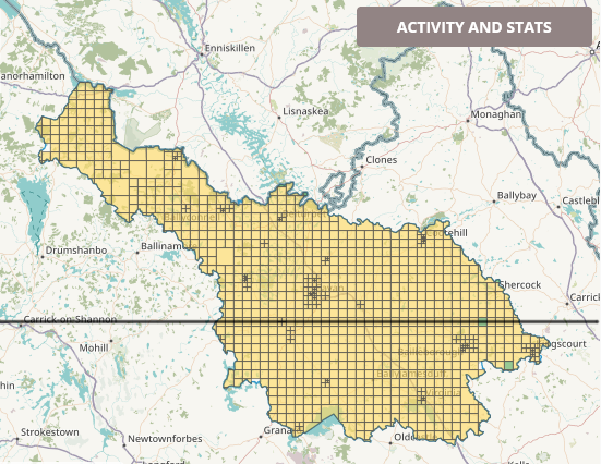
At 5:20 pm on 12/12/2022, the mapping part of the Cavan task was finished today*. Special thanks go to local mapper AdrianLangtry who did great ground work in Cavan and Ballyjamesduff as well as to mapillary constributors debigc and Elomur for providing fresh mapillary imagery focussing on Virginia which was also very useful for mapping details. Lets hope we can keep those two new-ish mappers interested…
*Sounds like a birth announcement, and rightly so.
One of the challenges mapping Co. Cavan was the imagery. The northern part had very clear, fairly recent Bing imagery. This part of Co. Cavan was finished first, because it was motivating to use clear imagery. For the southern part, Esri Clarity was the fall back with occasional use (should have been more) of Maxar. Maxar should definitely be used there for the validation process.
Buildings
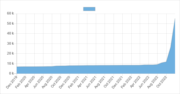
The number of buildings during the duration of the #osmIRL_buildings in Co. Cavan campaign (up to 05/12/2022) increased from 6,900 to 55,300, according to ohsome.org/apps/dashboard splitting into
| building type | number on 12/12/2022 |
|---|---|
| – | 73,500 |
| yes | 29,225 |
| house | 27,265 |
| terrace | 772 |
| detached | 292 |
| semidetached_house | 583 |
| farm_auxiliary | 10,306 |
| garage | 4,069 |
| shed | 3,119 |
| greenhouse | 439 |
| industrial | 248 |
| retail | 155 |
| commercial | 138 |
| church | 120 |
| school | 101 |
| hotel | 39 |
| static_caravan | 24 |
| hospital | 11 |
| ruins | 706 |
Highways
The total length of mapped highways during the campaign increased from 3,871km to 5,497km (increase of 42%).
Other car related features
Due to the excellent imagery, it was possible to add highway=stop (increase from 138 to 273) as written on roads and disabled parking spaces (increase from 4 to 101). This was, of course, only possible with the new Bing imagery.
Landuse
Due to the number of lakes in Co. Cavan (allegedly 365, should definitely be possible to be counted now), many of which had been partly drained in the past, great areas of wetland were added also during this task.
| landuse | area | increase on OSM since 2019 |
| natural=wetland | 229.km2 | 1305% |
| forest | 124km2 | 103% |
| residential | 16.2km2 | 67.9% |
| natural=wood | 11km2 | 74.3% |
| grass | 0.9km2 | 55% |
| farmland* | 2.2km2 | 32.1% |
Historic features
Because it was myself that was in it, many “new” historic features (sounds like an oxymoron) were added as well. Apart from the at least 3 newly discovered crannógs, that is.
| historic feature | total number as of Dec 2022 |
| ringfort | 204 |
| crannóg | 86 |
| megalith | ~24 |
| church | 19 |
| holy well | 14 |
| castle | 7 |
| cillín | 1 |
To do for validation
As per usual, the number of building=yes can probably be reduced. It would also be useful to use Maxar imagery in the second round to add possibly missing buildings and maybe even adjust road alignments.