

Open Data
#46 North Kerry task finished
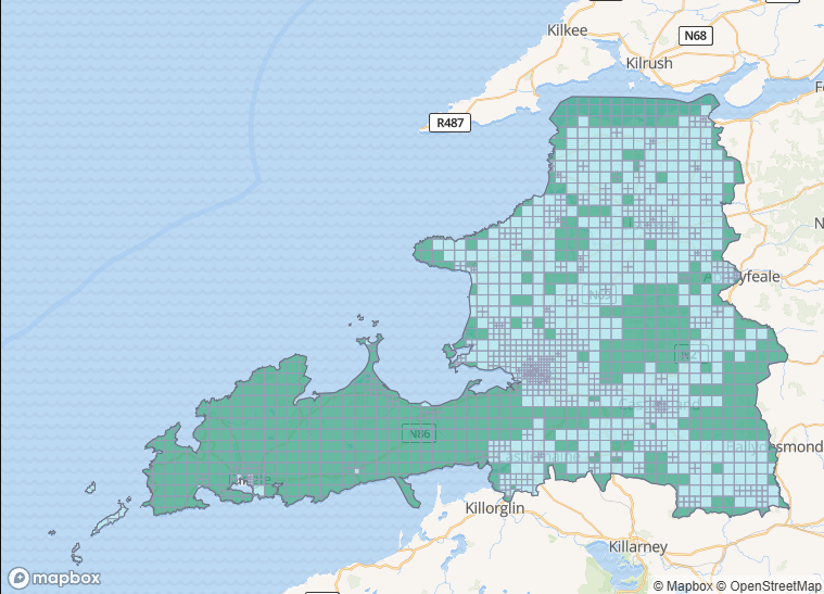
The mapping of task #46 North Kerry which had been opened on December 1st 2020 was concluded on May 17th 2026. Like so many others, it had been paused to reduce the number of open Read more
Volunteers create the maps for OpenStreetMap. It is easy to get started. Click here to find out how!
Developers can use the maps and data from OpenStreetMap directly in their projects. Find out how!
We are a voluntary organisation and would like to encourage you to become a member
Get notified by email of annoucements, events and tutorials

Visualising your data using OpenStreetMaps has never been easier. Watch tutorials about OverpassTurbo and D3.

You can still contribute to the map without a computer. Our favourite mobile tools are StreetComplete (Android - download app) and OSMAnd (Android and iOS -download app).
If you would like to contribute street view imagery we recommend Mapillary. The street images from Mapillary can then be used to help with mapping tasks. Visit their website or download the app (Android or iOS).

Overpass Turbo is a tool for advanced users and allows running queries against the map database. An example might be to show all car parks in an area.

JOSM is a Java application that can be used on Linux, Mac or Windows. This is an advanced tool for quicker editing for those who want to move on from the ID editor. Download here.
We regularly run task missions to map particular places or themes. The OSM Ireland Task website is the best place to monitor what needs done.

Provide map data to revolutionise disaster management, reduces risk, and contribute to achievement of the Sustainable Development Goals.

Use OnOSM.org to easily add a business to the Map
The mapping of task #46 North Kerry which had been opened on December 1st 2020 was concluded on May 17th 2026. Like so many others, it had been paused to reduce the number of open Read more
If you have been around OpenStreetMap Ireland for a while, you might be aware of the Buildings Project which was kicked off in November 2019 in Kilkenny. This conveniently came just before the country went Read more
On March 16, Priscilla from TomTom’s OSM Community team (pzachee) posted in the OSM Ireland Telegram group about a task they had created in the US task manager for Ballybricken where they wanted all buildings Read more
You can chat to us on Telegram
The OpenStreetMap Ireland Category is here
Upcoming mapathons are listed on EventBrite here. We try to hold monthly online sessions to chat and learn from others.