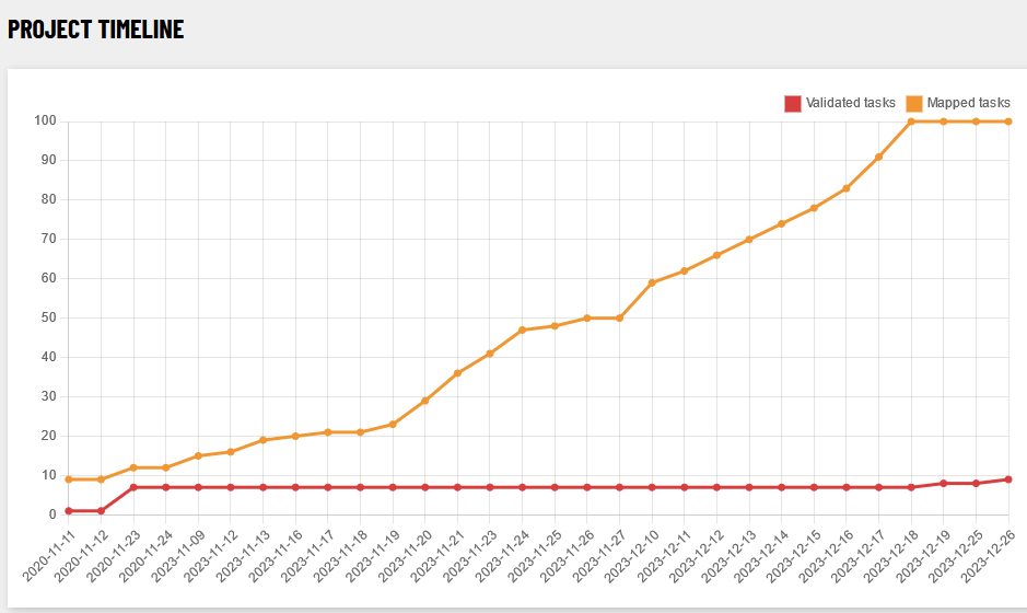
The Fingal task (no. 20) was yet another task that had been begun in 2020, but had been de-activated in favour of other tasks in November of 2020. It was re-activated on November 9th 2023 and the mapping finished on December 18th of 2023.
Contributors
There were 14 total contributors, 13 mappers and 6 validators (as of 2023-12-26). They were
| user name | tasks mapped | tasks validated |
|---|---|---|
| b-unicycling | 1230 | 5 |
| eireidium | 21 | 37 |
| Jonako | 48 | 0 |
| ibanez | 0 | 47 |
| DeBigC | 13 | 11 |
| jonnymccullagh | 12 | 5 |
| GovernorKeagan | 1 | 15 |
| tshedy | 8 | 0 |
| Smef09 | 5 | 0 |
| thommcg | 5 | 0 |
| tadcan | 2 | 0 |
| Schiefkopfschnecke | 1 | 0 |
| HeikkiVesanto | 1 | 0 |
| NickMillerUK | 1 | 0 |
Building numbers
| building type | number 2007 | number 30/11/2019 (start of buildings project) | number 20/11/2023 | number 15/12/2023 |
|---|---|---|---|---|
| 29 | 57,300 | 92,700 | 110,000 | |
yes | 26,500 | 14,000 | ||
house | 0 | 21,500 | 47,800 | 63,200 |
semidetached_house | 0 | 556 | 6,700 | 15,900 |
detached | 0 | 18 | 974 | 3,700 |
terrace | 1 | 264 | 338 | 316 |
residential | 0 | 765 | 796 | 731 |
apartments | 1 | 369 | 734 | 1,100 |
garage | 0 | 58 | 641 | 1,200 |
shed | 0 | 1,900 | 4,800 | 5,300 |
farm2 | 0 | 3 | 5 | 7 |
farm_auxiliary | 0 | 14 | 680 | 1,300 |
public | 1 | 7 | 10 | 14 |
retail | 6 | 124 | 330 | 411 |
commercial | 0 | 174 | 261 | 266 |
school | 4 | 125 | 182 | 205 |
church | 0 | 41 | 65 | 66 |
college | 0 | 8 | 8 | 10 |
hospital | 0 | 26 | 38 | 40 |
hangar | 0 | 01 | 1 | 15 |
ruins | 35 | 80 | ||
demolished:building | 89 | 120 |
2 For simplicity’s sake, often mapped as
building=house or building=detached.Mapping saturation
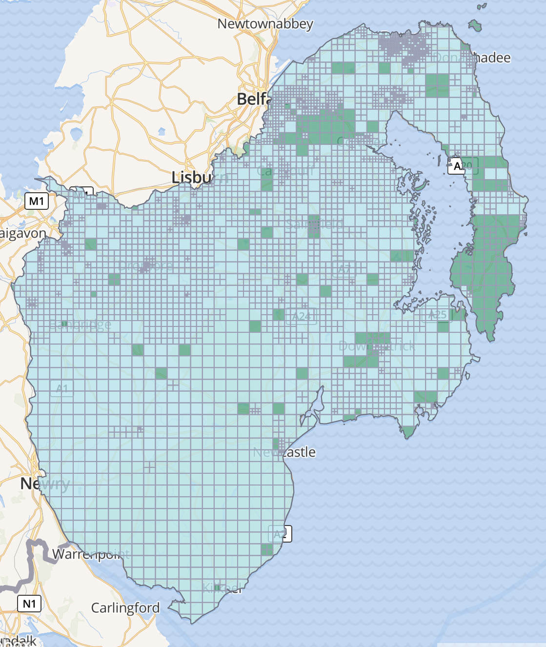
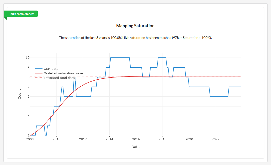
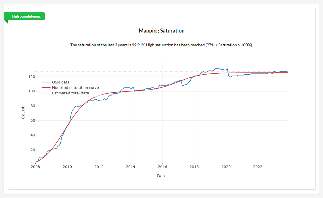
The OSM quality analysis tab by HeiGit allows to analyse the saturation of certain building types and amenities in a certain area and compares it with the mapping status. Two examples for Fingal:
Mapping saturation for hospitals
Mapping saturation for schools
Observations
The reason why it only took just over a month to finish the task (with b-unicycling dedicating 10 days of that to a private Kilkenny project) was that many buildings had been mapped independent of the task, likely by local mappers, possibly in Swords…maybe? It also helped that Lusk had had its own task earlier this year with recent enough imagery and in-person visits for mapillary capturing.
Very positive is the good coverage of house numbers, there were/ are even address interpolations for areas where there still are no buildings available on aerial imagery. Well done!
| addr tag | number 18/12/2023 |
|---|---|
addr:housenumber | 35,100 |
addr:housename | 853 |
addr:flat | 0 |
addr:street | 43,700 |
addr:city | 8,100 |
addr:postcode | 846 |
Something that seemed strange in Fingal is someone having mapped many buildings with roof:shape=pitched (2,800 cases by 18/12/2023) which is not a documented tag. The preferred and documented alternatives are either roof:shape=gabled or roof:shape=hipped. Should we have a MapRoulette task for that?
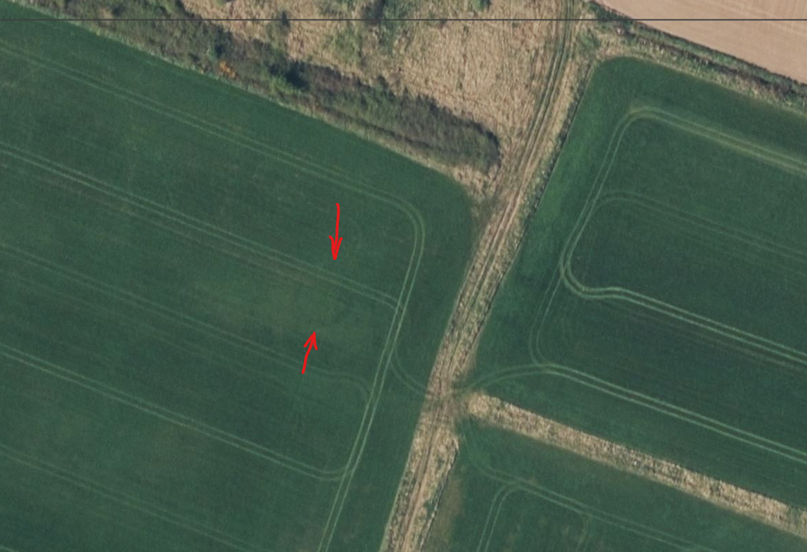
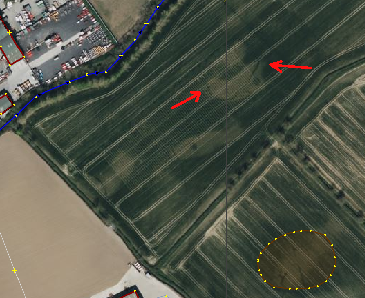
Archaeology
Two hitherto unrecorded archaeological sites were discovered on the newish Bing imagery in the last month, one in the townland of Corballis, one in the townland of Broghan. They have since been added to the records of the National Monuments Service, but have not made their way onto the Historic Environment Viewer.
Thatched buildings
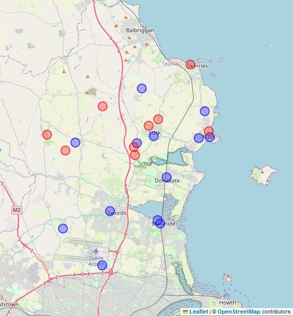
Several buildings and buildings part with roof:material=thatch were identified in person, on street-level imagery and Bing and mapped accordingly. The graphic below shows the locations with the blue dots representing buildings on the National Inventory for Architectural Heritage, mapped with ref:IE:niah.