The Drogheda task was finished on November 6th 2023, but is still awaiting some validation (EDIT 2023-12-16: All done now.). The task comprised of Drogheda town and rural areas to the north of the town.
It had, once again, been one of those tasks that had been parked in 2020 in favour of keeping fewer active tasks. It was re-activated on November 5th, when very little was left to be done.
Contributors
The task had 20 contributors; the top 10 were:
| user name | tasks total | tasks mapped | tasks validated |
|---|---|---|---|
| b-unicycling | 282 | 137 | 146 |
| jonnymccullagh | 114 | 1 | 113 |
| ibanez | 90 | 11 | 79 |
| Ivandor | 62 | 62 | 0 |
| eireidium | 60 | 11 | 49 |
| DeBigC | 56 | 33 | 23 |
| Jonako | 37 | 37 | 0 |
| ᚛ᚐᚋᚐᚅᚇᚐ᚜ | 31 | 31 | 0 |
| tadcan | 25 | 25 | 0 |
| NoelB | 18 | 18 | 0 |
| Smef09 | 16 | 6 | 10 |
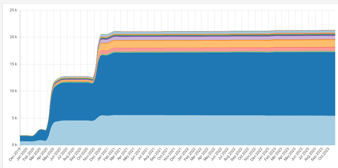
| tag | no. in 2019 | no. 2023-11-11 |
|---|---|---|
building | 1,700 | 21,200 |
yes | 629 | 5,400 |
house | 1,000 | 11,800 |
detached | 0 | 50 |
semidetached_house | 0 | 94 |
terrace | 0 | 152 |
residential | 25 | 119 |
garage | 0 | 688 |
shed | 4 | 1,300 |
greenhouse | 0 | 38 |
public | 0 | 0 |
school | 4 | 26 |
retail | 2 | 46 |
commercial | 8 | 58 |
hotel | 0 | 2 |
industrial | 13 | 134 |
farm_auxiliary | 6 | 669 |
barn | 0 | 100 |
church | 4 | 19 |
mosque | 0 | 0 |
ruins | 1 | 19 |
Thank you to all the contributors so far and happy validating!
1 Comment
Buildings Project 2019-2023 – OpenStreetMap Ireland · 21-Mar-2024 at 09:30
[…] Roscommon in March, the 2nd round of Celbridge in May, Balbriggan in June, Co. Meath in October, Drogheda and Bray in November, Fingal in December, and b-unicycling mapped a second round of Co. Kilkenny in […]
Comments are closed.