OpenStreetMap IrelandOpenStreetMap Ireland
  • Home
  • About
    • Membership
    • Corporate Members
    • Member Login
    • Who uses OpenStreetMap?
  • Learning
    • For Beginners
    • For Historians
      • How to fix wrong townland names spotted on townlands.ie
    • For Educators
    • For Developers
    • Tools
      • Mapillary street-level imagery
      • Panoramax Street-Level Imagery
      • OSMAnd Mobile App
      • Visualising Your Contributions
      • Using overpass-turbo to extract data from OpenStreetMap
  • Missions
    • AED Defibrillator Mapping
    • Current Mission Tasks
    • Completed Missions
      • Mapping Progress per County
      • Balbriggan
      • Celbridge
      • Connemara
      • County Cavan
      • County Clare – North
      • County Donegal
      • County Leitrim
      • County Roscommon
      • Longford Town
      • #MapLesotho
      • MapPatrick 2021
      • Wild Atlantic Way
  • News
  • Léarscáil
  • Contact

Townland Heat Map

Published by OSM Ireland on 27-Jan-201627-Jan-2016

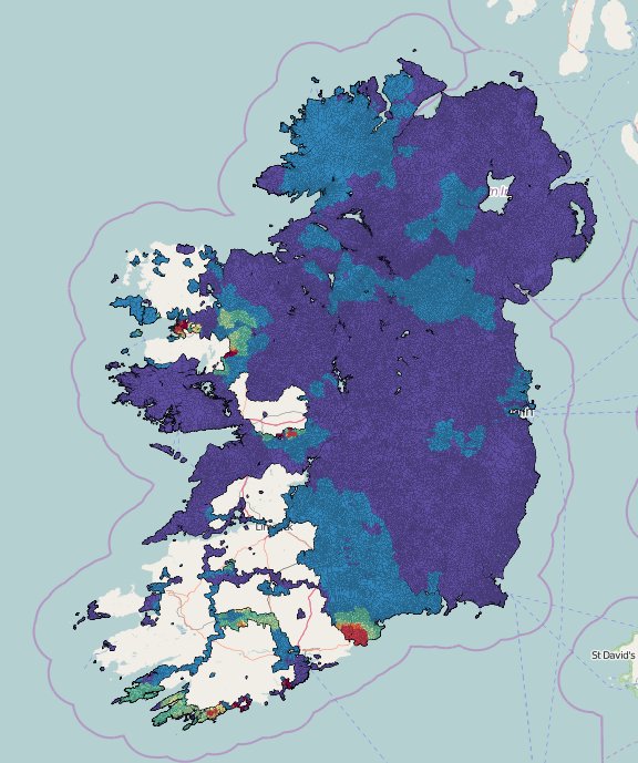
Rory has added a nice heatmap to the townlands.ie website ( http://www.townlands.ie/page/maps/ ) which changes colour based on when the townland was added to the database. The image below shows the state of play on the 27th January 2016.

Townland Heat Map

Categories: Townlands

Recent Posts
  • OpenStreetMap Ireland online meetup – May 2025
  • Louth (minus Dundalk) Task Mapped
  • Dundalk Task Complete
  • How to fix wrong townland names spotted on townlands.ie
  • Panoramax Street-Level Imagery
Upcoming Events (Global)
  • Моршанская картопати 2025
  • OpenStreetMap x Wikidata Taipei #77
  • 2025 júniusi OSM találkozó Budapesten
  • OSM Utah Monthly Map Night
  • Reunião da UMBRAOSM
  • Hamburger Mappertreffen
  • South Bay Map Night
OSM for History Buffs
  • Searching old street names in OpenStreetMap
  • From gravestone to 3D model - photogrammetry and heritage
  • St Moling's Well Listerlin
  • Rathlogan: Tobar na súil
  • Kiltrassy Church Well
Forum Discussions
  • Old Ordnance Survey maps in JOSM
  • Missing Post Offices in Northern Ireland
  • Ireland – Fix Incorrect Highway Junctions
  • Finding broken relations with Overpass
  • Ireland - Fix Spiky Buildings (updated)

Related Posts

adding changeset comment for fixing townland name
History

How to fix wrong townland names spotted on townlands.ie

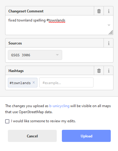
This issue arises frequently in our Facebook group when people “report” a wrongly spelled townland name on townlands.ie which, of course, gets its data from OpenStreetMap. The error cannot be fixed on townlands.ie directly, but Read more…

Competition

Announcing #MapPatrick21

Five days of mapping fun: Wed March 17th to Sunday March 21st The Christian Saint – Patrick – may have lots of doubts over who he was, where he came from, when his adventures in Read more…

OSMIE

Targets hit this week – 23rd December 2015

The OSM community have just surpassed the 47,000 townlands mark!  Earlier last week http://www.townlands.ie, stopped updating (new townlands stopped appearing as they were added).   After an investigation into the problem it was found that Read more…

OpenStreetMap Ireland Company Limited Registered company number 638034

General
  • Log in
  • Entries feed
  • Comments feed
  • WordPress.org
Categories
Archives

  • Home
  • About
  • Learning
  • Missions
  • News
  • Léarscáil
  • Contact
Hestia | Developed by ThemeIsle

OpenStreetMap Ireland Cookies Policy

Our Website uses cookies to improve your experience. Please visit our Privacy Policy page for more information about cookies and how we use them.

Close