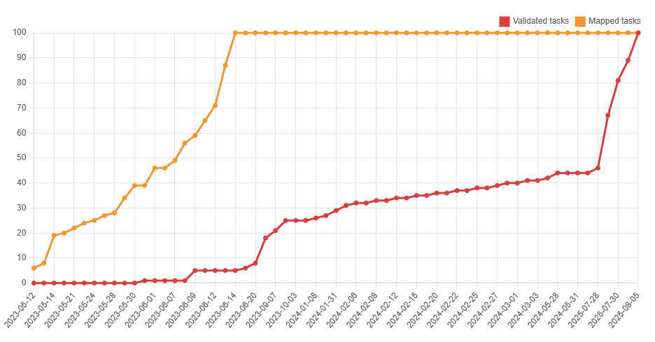
OpenStreetMap IrelandOpenStreetMap Ireland
  • Home
  • About
    • Membership
    • Corporate Members
    • Member Login
    • Who uses OpenStreetMap?
  • Learning
    • For Beginners
    • For Historians
      • How to fix wrong townland names spotted on townlands.ie
    • For Educators
    • For Developers
    • Tools
      • Mapillary street-level imagery
      • Panoramax Street-Level Imagery
      • OSMAnd Mobile App
      • Visualising Your Contributions
      • Using overpass-turbo to extract data from OpenStreetMap
  • Missions
    • AED Defibrillator Mapping
    • Current Mission Tasks
    • Completed Missions
      • Mapping Progress per County
      • Balbriggan
      • Celbridge
      • Connemara
      • County Cavan
      • County Clare – North
      • County Donegal
      • County Leitrim
      • County Roscommon
      • Longford Town
      • #MapLesotho
      • MapPatrick 2021
      • Wild Atlantic Way
  • News
  • Léarscáil
  • Contact

2025

Events

OpenStreetMap Ireland online meetup – May 2025

Join us for a dive into how Large Language Models (LLMs) and an MCP (Model Context Protocol) Server can be combined to build an AI-powered chatbot that queries the OpenStreetMap (OSM) database. This session will demonstrate the working code—available on GitHub—for both the backend and frontend components.

By Donal Hunt, 4 weeks12-May-2025 ago
OSM Ireland Buildings

Louth (minus Dundalk) Task Mapped

On Valentine’s Day this year (pure coincidence, I’m sure), the Louth task was finished. Dundalk had been excluded from the task, because it had had its own task previously. The task had been opened on the 12th of November 2024, so it took only about three months to complete. To Read more…

By Anne-Karoline, 3 months23-Mar-2025 ago
Recent Posts
  • OpenStreetMap Ireland online meetup – May 2025
  • Louth (minus Dundalk) Task Mapped
  • Dundalk Task Complete
  • How to fix wrong townland names spotted on townlands.ie
  • Panoramax Street-Level Imagery
Upcoming Events (Global)
  • Моршанская картопати 2025
  • OpenStreetMap x Wikidata Taipei #77
  • 2025 júniusi OSM találkozó Budapesten
  • OSM Utah Monthly Map Night
  • Reunião da UMBRAOSM
  • Hamburger Mappertreffen
  • South Bay Map Night
OSM for History Buffs
  • Searching old street names in OpenStreetMap
  • From gravestone to 3D model - photogrammetry and heritage
  • St Moling's Well Listerlin
  • Rathlogan: Tobar na súil
  • Kiltrassy Church Well
Forum Discussions
  • Old Ordnance Survey maps in JOSM
  • Missing Post Offices in Northern Ireland
  • Ireland – Fix Incorrect Highway Junctions
  • Finding broken relations with Overpass
  • Ireland - Fix Spiky Buildings (updated)

OpenStreetMap Ireland Company Limited Registered company number 638034

General
  • Log in
  • Entries feed
  • Comments feed
  • WordPress.org
Categories
Archives

  • Home
  • About
  • Learning
  • Missions
  • News
  • Léarscáil
  • Contact
Hestia | Developed by ThemeIsle

OpenStreetMap Ireland Cookies Policy

Our Website uses cookies to improve your experience. Please visit our Privacy Policy page for more information about cookies and how we use them.

Close