OpenStreetMap IrelandOpenStreetMap Ireland
  • Home
  • About
    • Membership
    • Corporate Members
    • Member Login
    • Who uses OpenStreetMap?
  • Learning
    • For Beginners
    • For Historians
      • How to fix wrong townland names spotted on townlands.ie
    • For Educators
    • For Developers
    • Tools
      • Mapillary street-level imagery
      • Panoramax Street-Level Imagery
      • OSMAnd Mobile App
      • Visualising Your Contributions
      • Using overpass-turbo to extract data from OpenStreetMap
  • Missions
    • AED Defibrillator Mapping
    • Current Mission Tasks
    • Completed Missions
      • Mapping Progress per County
      • Balbriggan
      • Celbridge
      • Connemara
      • County Cavan
      • County Clare – North
      • County Donegal
      • County Leitrim
      • County Roscommon
      • Longford Town
      • #MapLesotho
      • MapPatrick 2021
      • Wild Atlantic Way
  • News
  • Léarscáil
  • Contact

Map n Chat Easter 2026

Published by Jonny McCullagh on 01-Apr-202601-Apr-2026

Join us for an Easter Map & Chat online! Fun, educational chats while adding data to OpenStreetMap!

For the Easter 2026 Map & Chat b-unicycling and jonny will be demonstrating JOSM and sharing mapping techniques. Whether you’re a map whiz or just love a good chat, this event will have a casual community vibes. Grab your favorite snack, hop online, and let’s contribute some data to OpenStreetMap

https://www.eventbrite.ie/e/map-chat-easter-2026-tickets-1985666748698
Categories: FunMeetupsOpen Data
Tags: Communitymap & chat

Recent Posts
  • Belfast task (#115) complete
  • SW Limerick Task #114 Finished
  • #46 North Kerry task finished
  • State of the Buildings Map June 2026
  • Ballybricken task mapped
Upcoming Events (Global)
  • Missing Maps London Mid-Month for Advanced Mappers (no training provided) (Online) [eng]
  • Mappy Hour OSM España
  • Bay Area WikiSalon
  • Réunion du groupe local de Lyon
  • 22. Österreichischer OSM-Stammtisch (online)
  • OSM-Stammtisch Chemnitz
  • South Bay Map Night
OSM for History Buffs
  • Recycled stone at Kyteler's Inn
  • A recycled stone from St Francis' Franciscan Friary #StoneMadShorts
  • Mapping fish weirs on OpenStreetMap
  • How to use street-level imagery for mapping
  • Wheelchair Accessibility on OpenStreetMap
Forum Discussions
  • Clonskeagh Road cycle routing issue (OSRM)
  • New Maproulette challenge: Ireland - Connectivity and Geometry Issues on Highways
  • Fake hamlets in County Longford?
  • Corrupted boundary between Connacht and Munster
  • Correcting dud post codes (mostly EirCodes)

Related Posts

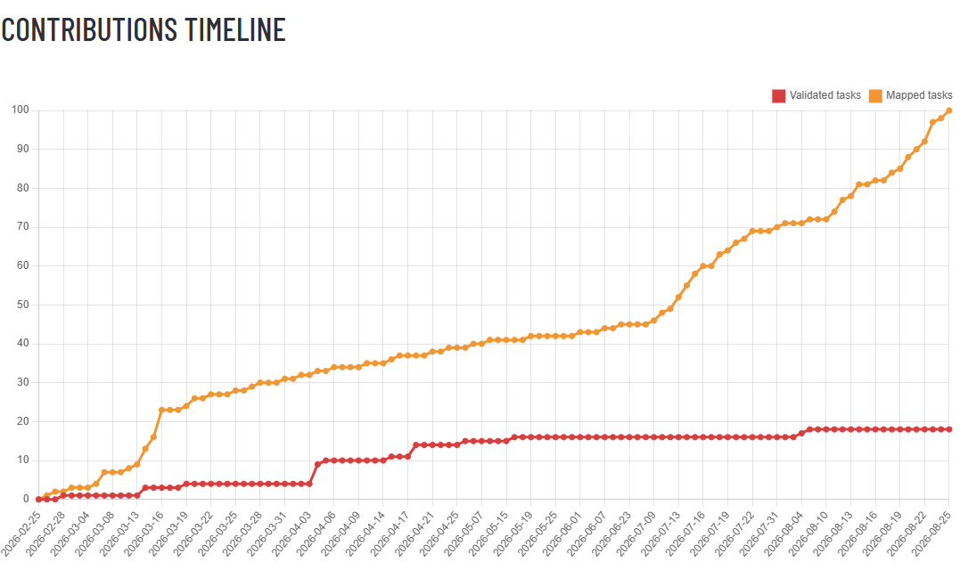
statistics for the mapping of the Belfast task between February and August of 2026
Open Data

Belfast task (#115) complete

The Belfast task had been created by Johnny on February 25 2026. It benefitted from the earlier Co. Down task which had seen East Belfast tackled. The tiles were small and the imagery (Bing) excellent, Read more

Open Data

SW Limerick Task #114 Finished

On July 3rd, the SW Limerick task (#114) had been finished mapping on the task manager. Five contributors had worked on the task with b-unicycling having mapped 1055 and validating 2 tasks, jonnymccullagh having mapped Read more

Open Data

#46 North Kerry task finished

The mapping of task #46 North Kerry which had been opened on December 1st 2020 was concluded on May 17th 2026. Like so many others, it had been paused to reduce the number of open Read more

OpenStreetMap Ireland Company Limited Registered company number 638034

General
  • Log in
  • Entries feed
  • Comments feed
  • WordPress.org
Categories
Archives

  • Home
  • About
  • Learning
  • Missions
  • News
  • Léarscáil
  • Contact
Hestia | Developed by ThemeIsle

OpenStreetMap Ireland Cookies Policy

Our Website uses cookies to improve your experience. Please visit our Privacy Policy page for more information about cookies and how we use them.

Close