OpenStreetMap IrelandOpenStreetMap Ireland
  • Home
  • About
    • Membership
    • Corporate Members
    • Member Login
    • Who uses OpenStreetMap?
  • Learning
    • For Beginners
    • For Historians
      • How to fix wrong townland names spotted on townlands.ie
    • For Educators
    • For Developers
    • Tools
      • Mapillary street-level imagery
      • Panoramax Street-Level Imagery
      • OSMAnd Mobile App
      • Visualising Your Contributions
      • Using overpass-turbo to extract data from OpenStreetMap
  • Missions
    • AED Defibrillator Mapping
    • Current Mission Tasks
    • Completed Missions
      • Mapping Progress per County
      • Balbriggan
      • Celbridge
      • Connemara
      • County Cavan
      • County Clare – North
      • County Donegal
      • County Leitrim
      • County Roscommon
      • Longford Town
      • #MapLesotho
      • MapPatrick 2021
      • Wild Atlantic Way
  • News
  • Léarscáil
  • Contact

2023

OSM Ireland Buildings

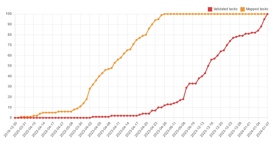
Co. Monaghan Task – Mapping Complete

As task no. 100, I created one for County Monaghan after a certain person complained that it had been neglected so far. It was created as a private task that only team members could work on (whoever “the team” is), because I wanted to look for unrecorded archaeological sites and Read more

By Anne-Karoline, 2 years23-Jan-2024 ago
OSM Ireland Buildings

Connemara Task – Validation Complete!

On January 7th 2024, the validation on the Connemara task (#17) was finished. A big thank you to all who made the effort! Top 10 Validators (There happened to be just those 10 validators.) username no. of tasks validated jonnymccullagh 1,035 b-unicycling 284 Eoin O’Mahony 31 Coirib 19 IpswichEdits 9 Read more

By Anne-Karoline, 2 years23-Jan-2024 ago
Meetups

OpenStreetMap Ireland AGM 2023

Join us on November 4 for the AGM of the OSM Ireland chapter…

By Donal Hunt, 2 years08-Oct-2023 ago
Recent Posts
  • Belfast Mapathon
  • North Co. Galway task mapping finished
  • North Co. Clare validation complete!
  • Townland boundary overpass links
  • OpenStreetMap Ireland Annual General Meeting
Upcoming Events (Global)
  • Karlsruhe Hack Weekend February 2026
  • OSM Mumbai Mapping Party No.7 (Western Line - South)
  • Missing Maps : Mapathon en ligne - CartONG [fr]
  • Rencontre Saint-Étienne et sud Loire
  • Únorový olomoucký mapathon
  • Cartopartie
  • Mappy Hour OSM España
OSM for History Buffs
  • Mapping Eleventh Night Bonfires Sites on OpenStreetMap
  • Mapping quarries on OpenStreetMap
  • Hermit's Well at Clontubbrid #holywell #irishholywells #fiacra #fiachre
  • Ballyellin Church date? #archaeology #citizenscience #CarlowHistory
  • Brigid's Well in Toberbreedia, Kilkenny #saintbrigid #brigidswell
Forum Discussions
  • Anyone familiar with bus routings in Derry around Foyle St and Craigavon Bridge?
  • Remove English from Gaeltacht placenames
  • Archaeological site
  • A technical query re OSM vs. Translink's Open bus stop Data
  • BnM railways bulk edit

OpenStreetMap Ireland Company Limited Registered company number 638034

General
  • Log in
  • Entries feed
  • Comments feed
  • WordPress.org
Categories
Archives

  • Home
  • About
  • Learning
  • Missions
  • News
  • Léarscáil
  • Contact
Hestia | Developed by ThemeIsle

OpenStreetMap Ireland Cookies Policy

Our Website uses cookies to improve your experience. Please visit our Privacy Policy page for more information about cookies and how we use them.

Close