OpenStreetMap IrelandOpenStreetMap Ireland
  • Home
  • About
    • Membership
    • Corporate Members
    • Member Login
    • Who uses OpenStreetMap?
  • Learning
    • For Beginners
    • For Historians
    • For Educators
    • For Developers
    • Tools
      • Mapillary
      • OSMAnd Mobile App
      • Visualising Your Contributions
  • Missions
    • AED Defibrillator Mapping
    • Current Mission Tasks
    • Completed Missions
      • Balbriggan
      • Celbridge
      • Connemara
      • County Cavan
      • County Clare – North
      • County Donegal
      • County Leitrim
      • County Roscommon
      • Longford Town
      • #MapLesotho
      • MapPatrick 2021
      • Wild Atlantic Way
  • News
  • Léarscáil
  • Contact

Uncategorized

Uncategorized

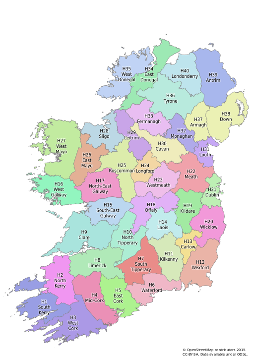
Irish Vice Counties

I’ve been meaning to write about OpenStreetMap Ireland‘s townland mapping project for some time. It’s a wonderful example of how historical maps are of significant value in creating really useful data on OpenStreetMap which is just as relevant as it today as was in the past. The immediate reason for Read more…

By OSM Ireland, 8 years16-Nov-2015 ago
Uncategorized

The bendiest roads in the world, by Rory McCann

Although created a long time ago, Rory’s work has popped up again, this time on Jalopnik. Check out the article here

By DaCor, 8 years ago

Posts navigation

Previous 1 2
Recent Posts
  • Drogheda Task Finished
  • Bray Task Finished
  • Co. Meath finished
  • OpenStreetMap Ireland AGM 2023
  • Léarscáil na hÉireann
Upcoming Events (Global)
  • OpenStreetMap India - WB Team Meetup
  • OSMmapperCPH
  • Mapathon débutant saison 23/24 CartONG
  • Budapest OSM Meetup 2023 December
  • OSM-Stammtisch
  • Debriefing Cartopartie à vélo du samedi 9 déc à Saint-Martin-d'Hères
  • OpenStreetMap x Wikidata Taipei #59
OSM for History Buffs
  • Reporting a possible monument to the National Monuments Service of Ireland
  • Mapping Fox Coverts
  • Mapping Doorstep Details
  • Validation process in the Task Manager for osmIRL buildings
  • Exploring and mapping pavement lights
Forum Discussions
  • Fixing incorrect junctions on roundabouts in Ireland
  • Unusual and not documented shop values in Ireland
  • Townland naming
  • Fixing incorrect highway junctions
  • OSM Ireland Annual General Meeting 2023

OpenStreetMap Ireland Company Limited Registered company number 638034

General
  • Log in
  • Entries feed
  • Comments feed
  • WordPress.org
Categories
Archives

  • Home
  • About
  • Learning
  • Missions
  • News
  • Léarscáil
  • Contact
Hestia | Developed by ThemeIsle

OpenStreetMap Ireland Cookies Policy

Our Website uses cookies to improve your experience. Please visit our Privacy Policy page for more information about cookies and how we use them.

Close