The following was originally posted by rorym in his OSM Diary. Original entry here
In the UK they are doing a quarterly project to map more schools and there is a list of schools in Ireland from the Department of Education, but that only has addresses, not locations.
I thought I’d download that file and throw it at Nominatim and see if we can’t geocode those addresses, and have something to work with. I thought with all the mapped townlands, that Nominatim might be OK at some of the rural addresses.
The results are not good.
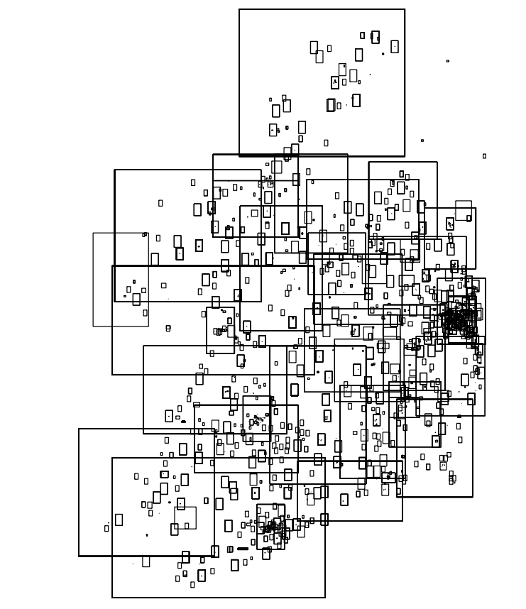
Nominatim returns a bounding box for a result. Here’s what happens when you try to geocode all the primary schools:
The big boxes are where Nominatim was only able to get the county. You can see that many other boxes are just around towns and villages. Nothing more detailed than that. The map might as well be a map of “Counties and Towns of Ireland”, which is useless for locating schools.
An example address is “SCOIL NAOMH MICHEAL,SNEEM,CO KERRY”. It’s no surprise that Nominatim cannot get any more accurate than the village of Sneem in that case. The other school in Sneem, SCOIL EOIN,TAHILLA,SNEEM,CO. KERRY, is hardly more accurate.
The code is in the “ie-schools-geocode” repository on our github Run “make install primary-schools-areas.shp” to generate the data. The geocoding is done in “geocode-single.sh”
That image is based on the shapefile in primary-schools-areas.zip. If you don’t want to generate the data, you can just download it directly from github. By using the Open Data plug-in you can open it in JOSM.
Unfortunately, it looks like the schools list database isn’t very useful for mapping all the schools.
Irish addresses, eh?
2 Comments
gott · 10-Feb-2016 at 02:13
follow this trail: http://www.schooldays.ie/articles/primary-Schools-in-Ireland-by-map
it might lead you to a useful list.
i found your first example with overpass. the second one was not easy, but then i stumbled upon the whole picture
stas · 13-Nov-2018 at 13:39
Late to the party, but looking at the latest list – they all have their eircode there as well. Is this considered a commercial source and unusable for the purposes of OSM?
Comments are closed.