The mapping of task #46 North Kerry which had been opened on December 1st 2020 was concluded on May 17th 2026. Like so many others, it had been paused to reduce the number of open tasks in 2021 and was re-opened in December of 2025. The area had partly been affected by the Wild Atlantic Way mapping.
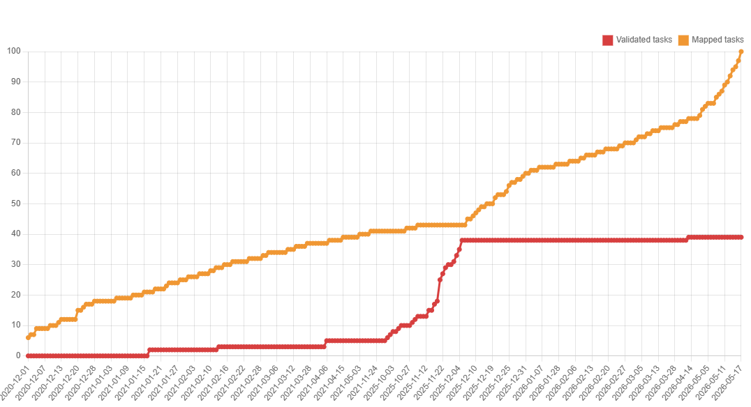
The Top5 mappers were b-unicycling (1,211 tasks), eireidium (677 tasks), DeBigC (17 tasks), kOSMofant (15 tasks) and amapanda ᚛ᚐᚋᚐᚅᚇᚐ᚜ 🏳️⚧️ (10 tasks). The Top 4 validators so far were b-unicycling (669 tasks), eireidium (60 tasks), Smef09 (22 tasks), Jonako (2 tasks) and several contributors who validated one task each. Many thanks to all the contributors of the many years on this project! 39% are already validated, but the validation is still open.
Buildings statistics
| tag | Number December 1st 2020 | Number December 1st 2025 | Number May 18th 2026 |
|---|---|---|---|
building | 5.7K | 43.1K | 79.5K |
building=yes | 4.4K | 7.2K | 14.1K |
building=house | 781 | 19.3K | 33.2K |
building=terrace | 1 | 1 | 2 |
building=apartments | 3 | 10 | 37 |
building=residential | 59 | 62 | 41 |
building=garage | 23 | 679 | 2.6K |
building=farm | 2 | 75 | 38 |
building=shed | 100 | 7.4K | 11K |
building=farm_auxiliary | 53 | 5.7K | 13.9K |
building=barn | 9 | 36 | 140 |
building=commercial | 14 | 137 | 199 |
building=retail | 11 | 179 | 289 |
building=industrial | 94 | 225 | 247 |
building=public | 0 | 1 | 4 |
building=school | 28 | 89 | 111 |
building=church | 39 | 61 | 64 |
building=greenhouse | 4 | 60 | 128 |
building=service | 1 | 3 | 5 |
building=ruins | 4 | 409 | 623 |
addr:street | 157 | 1.8K | 2.6K |
Other mapped features
| tags | numbers Dec 2020 | numbers May 18th 2026 |
|---|---|---|
landuse | 105 km2 | 223 km2 |
highway | 4,394 km | 6,581 km |
highway=crossing | 125 | 423 |
traffic_calming | 27 | 110 |
barrier=hedge | 120 km | 268 km |
barrier=wall | 110 km | 514 km |
power=pole | 3.9K | 9.7K |
highway=street_lamp | 0 | 152 |
amenity=grave_yard | 57 | 87 |
landuse=cemetery | 19 | 55 |
historic=archaeological_site1 | 885279.6 m2 | 2.2 km2 |
historic=archaeological_site | 517 | 1.5K |
1 Nine potential new (i.e. previously unrecorded) archaeological sites were reported to the National Monuments Service, six have been approved (SMR nos. KE054-098—-, KE016-082—-, KE002-065—-, KE038-169—-, KE054-099—-, KE038-170—-).
0 Comments