On March 16, Priscilla from TomTom’s OSM Community team (pzachee) posted in the OSM Ireland Telegram group about a task they had created in the US task manager for Ballybricken where they wanted all buildings mapped. In a DM, she said that Ballybricken had been chosen because “The gaps were flagged based on traffic patterns detected through the Copernicus Human Settlement dataset (https://human-settlement.emergency.copernicus.eu/) and aerial imagery.”
Uptake on the task was slow with only pzachee and OscarBrownbread mapping a few tiles. That was until Jonny (who is not in the Telegram group) asked me whether I had seen it. So I took a look, and jumped right in, and we finished the mapping within two or three days.
The preferred imagery set for the task is Bing which might or might not be the most recent imagery for that area – there were houses visible on Esri World which weren’t on Bing and vice versa. However, the Bing imagery is very blurry and makes mapping imprecise which resulted in building footprints mapped too large. It is also frustrating, when you’re spoiled by the crisp Bing imagery of the finished Co. Down task, for example, so Jonny and I decided to use the very outdated Esri Clarity imagery instead and check against the Esri World imagery for updates. The task has been archived, so validation is seemingly not required.
Statistics
Five users worked on the task: b-unicycling, jonnymccullagh, pzachee, Priscilla_Zachée and OscarBrownbread. Thanks to all these contributors.
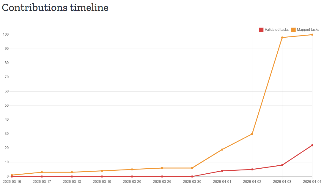
The dashboard for the tasks informs us that the task saw 5,244 total map edits and that 3,605 buildings and 34km of road were mapped (not that highways were required to map, but you might as well).
Building statistics
This task comprised rural areas with many farm auxiliary buildings.
| tag | number March 15th | number April 4th |
|---|---|---|
building | 301 | 3.8K |
building=yes | 76 | 1.1K |
building=house | 169 | 1.5K |
building=garage | 33 | 375 |
building-shed | 4 | 118 |
building=farm | 0 | 1 |
building=farm_auxiliary | 0 | 617 |
building=commercial | 7 | 12 |
building=retail | 2 | 4 |
building=industrial | 0 | 1 |
building=ruins | 1 | 36 |
building=school | 2 | 3 |
building=church | 3 | 3 |
Other statistics
| tag | number March 15th | number April 4th |
|---|---|---|
highway | 148 km | 181 km |
barrier=wall | 0.5517 km | 2.5 km |
barrier=hedge | 2.3 km | 12.4 km |
landuse | 5.3 km2 | 5.9 km2 |
power=pole | 884 | 993 |
amenity=grave_yard | 2 | 7 |
historic=archaeological_site* | 19 | 82 |
historic=archaeological_site | 51888.8 ㎡ | 396603.8 ㎡ |
* There were quite two impressive archaeological_site=field_system to be seen within the task which probably contained some unrecorded monuments, but other than that, there were no unrecorded monuments spotted this time, phew.
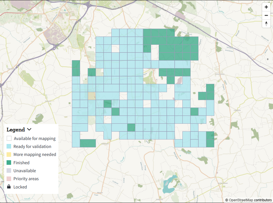
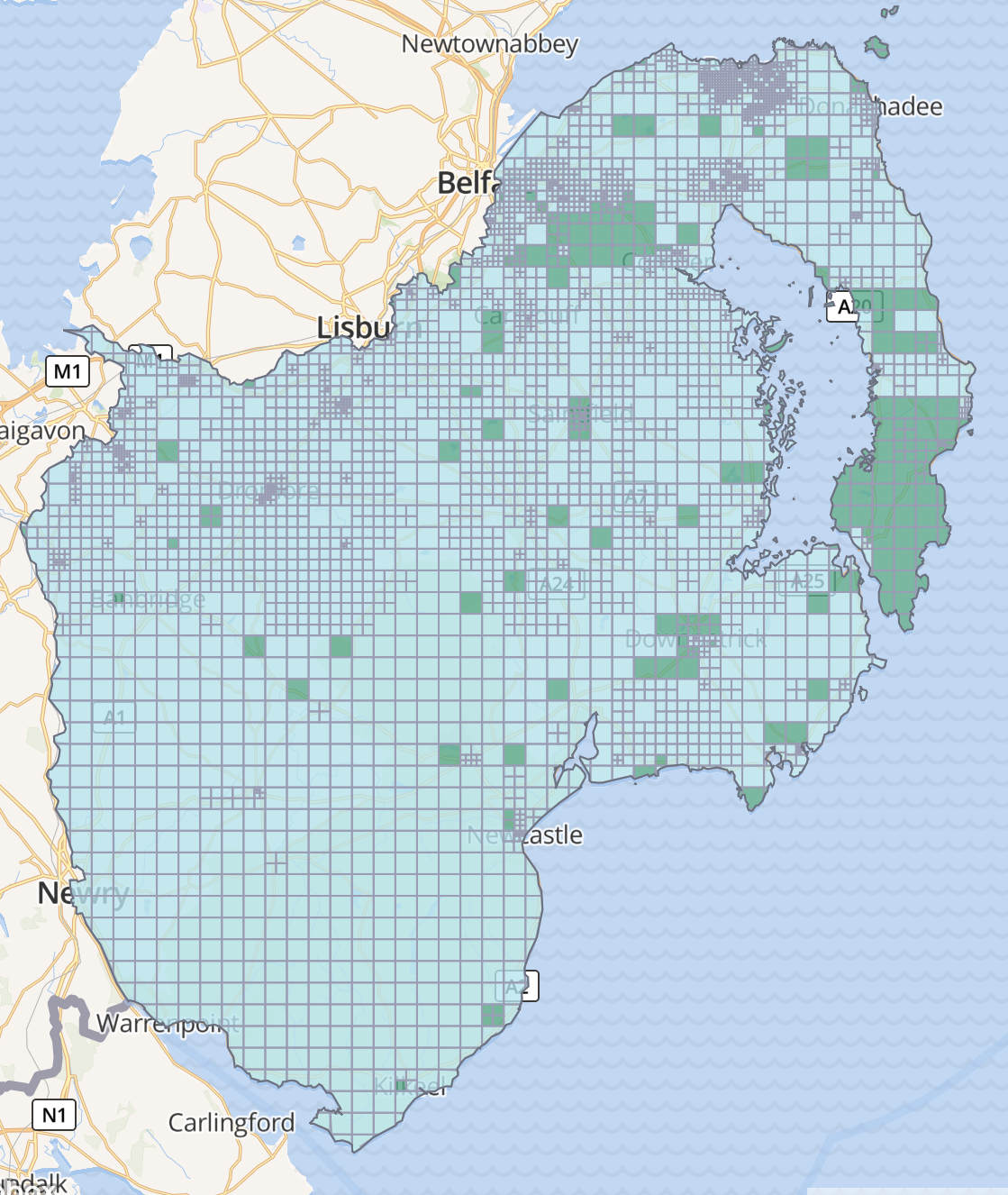
Back to our own task manager: The Belfast task as well as the North Kerry and SW Limerick tasks are still looking to be mapped.
0 Comments