OpenStreetMap IrelandOpenStreetMap Ireland
  • Home
  • About
    • Membership
    • Corporate Members
    • Member Login
    • Who uses OpenStreetMap?
  • Learning
    • For Beginners
    • For Historians
      • How to fix wrong townland names spotted on townlands.ie
    • For Educators
    • For Developers
    • Tools
      • Mapillary street-level imagery
      • Panoramax Street-Level Imagery
      • OSMAnd Mobile App
      • Visualising Your Contributions
      • Using overpass-turbo to extract data from OpenStreetMap
  • Missions
    • AED Defibrillator Mapping
    • Current Mission Tasks
    • Completed Missions
      • Mapping Progress per County
      • Balbriggan
      • Celbridge
      • Connemara
      • County Cavan
      • County Clare – North
      • County Donegal
      • County Leitrim
      • County Roscommon
      • Longford Town
      • #MapLesotho
      • MapPatrick 2021
      • Wild Atlantic Way
  • News
  • Léarscáil
  • Contact

January 27, 2016

Townlands

Townland Heat Map

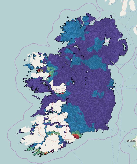
Rory has added a nice heatmap to the townlands.ie website ( http://www.townlands.ie/page/maps/ ) which changes colour based on when the townland was added to the database. The image below shows the state of play on the 27th January 2016.

By OSM Ireland, 10 years27-Jan-2016 ago
Recent Posts
  • Belfast Mapathon
  • North Co. Galway task mapping finished
  • North Co. Clare validation complete!
  • Townland boundary overpass links
  • OpenStreetMap Ireland Annual General Meeting
Upcoming Events (Global)
  • Mapathon OSM à La Base : cartographier Haïti pour la prévention des risques ​
  • Réunion des contributeurs de Montrouge et du Sud de Paris
  • Stammtisch Dresden
  • Workshop OpenStreetMap
  • OSM-Treffen Freiburg/Brsg.
  • OSMF Engineering Working Group meeting
  • Braunschweiger Mappertreffen im Stratum 0 Hackerspace
OSM for History Buffs
  • Brigid's Well in Toberbreedia, Kilkenny #saintbrigid #brigidswell
  • Splitting houses with perfect right angles in JOSM #OpenStreetMap #JOSM
  • Archaeological finds report January 2026 #citizenscience #archaeology #ireland
  • Earth Mortar at Ballyellin Church #buildingsarchaeology #earthmortar
  • Creating an interactive Down Survey map for County Kilkenny on uMap 49:09
Forum Discussions
  • Archaeological site
  • A technical query re OSM vs. Translink's Open bus stop Data
  • BnM railways bulk edit
  • Translink's new nightbuses
  • Ireland - Disconnected Barriers from Nearby Roads

OpenStreetMap Ireland Company Limited Registered company number 638034

General
  • Log in
  • Entries feed
  • Comments feed
  • WordPress.org
Categories
Archives

  • Home
  • About
  • Learning
  • Missions
  • News
  • Léarscáil
  • Contact
Hestia | Developed by ThemeIsle

OpenStreetMap Ireland Cookies Policy

Our Website uses cookies to improve your experience. Please visit our Privacy Policy page for more information about cookies and how we use them.

Close