OpenStreetMap IrelandOpenStreetMap Ireland
  • Home
  • About
    • Membership
    • Corporate Members
    • Member Login
    • Who uses OpenStreetMap?
  • Learning
    • For Beginners
    • For Historians
      • How to fix wrong townland names spotted on townlands.ie
    • For Educators
    • For Developers
    • Tools
      • Mapillary street-level imagery
      • Panoramax Street-Level Imagery
      • OSMAnd Mobile App
      • Visualising Your Contributions
      • Using overpass-turbo to extract data from OpenStreetMap
  • Missions
    • AED Defibrillator Mapping
    • Current Mission Tasks
    • Completed Missions
      • Mapping Progress per County
      • Balbriggan
      • Celbridge
      • Connemara
      • County Cavan
      • County Clare – North
      • County Donegal
      • County Leitrim
      • County Roscommon
      • Longford Town
      • #MapLesotho
      • MapPatrick 2021
      • Wild Atlantic Way
  • News
  • Léarscáil
  • Contact

The bendiest roads in the world, by Rory McCann

Published by DaCor on 03-Jul-2015

curvy

Although created a long time ago, Rory’s work has popped up again, this time on Jalopnik.

Check out the article here

Categories: Uncategorized

DaCor

I have been an active member of the OpenStreetMap community in Ireland for several years. I am also a project lead on the #MapLesotho project

Recent Posts
  • Townland boundary overpass links
  • OpenStreetMap Ireland Annual General Meeting
  • OSM 21st Birthday Online Mapathon
  • OpenStreetMap Ireland online meetup – May 2025
  • Louth (minus Dundalk) Task Mapped
Upcoming Events (Global)
  • Mapatón Nacional de México 2025
  • OSM India Online (Remote) Mapping Session
  • Missing Maps : Mapathon en ligne - CartONG [fr]
  • Workshop - Mobile Mapping for OpenStreetMap
  • OSM Utah Monthly Map Night
  • Hamburger Mappertreffen
  • Missing Maps - DRK & MSF Online Mapathon
OSM for History Buffs
  • Inistioge Cloister Reconstruction
  • Medieval grave slab discovered #medieval #kilkenny
  • St Brigid's Well, Ballintubbert (Co. Laois)
  • Holy wells and OpenData - a talk about Wikidata et al.
  • Easily add mapillary ID to node
Forum Discussions
  • Broken boundaries (September 2025 Edition)
  • OpenStreetMap Ireland Annual General Meeting 2025
  • Northern Ireland county vs new council boundaries
  • N21 to N20 junction at Patrickswell, Limerick
  • NI charity numbers

Related Posts

Meetups

OpenStreetMap Ireland AGM 2024

Join us on September 21 for the AGM of the OSM Ireland chapter...

Meetups

OpenStreetMap Ireland AGM 2023

Join us on November 4 for the AGM of the OSM Ireland chapter...

Uncategorized

Armchair archaeologist locates unknown crannógs

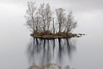
Mapper b-unicycling has had an article published about her discoveries in the Anglo Celt: An “armchair archaeologist” has literally put ancient Cavan crannógs on the map. Anne-Karoline Distel has discovered three previously unrecorded crannógs, which Read more

OpenStreetMap Ireland Company Limited Registered company number 638034

General
  • Log in
  • Entries feed
  • Comments feed
  • WordPress.org
Categories
Archives

  • Home
  • About
  • Learning
  • Missions
  • News
  • Léarscáil
  • Contact
Hestia | Developed by ThemeIsle

OpenStreetMap Ireland Cookies Policy

Our Website uses cookies to improve your experience. Please visit our Privacy Policy page for more information about cookies and how we use them.

Close