OpenStreetMap IrelandOpenStreetMap Ireland
  • Home
  • About
    • Membership
    • Corporate Members
    • Member Login
    • Who uses OpenStreetMap?
  • Learning
    • For Beginners
    • For Historians
      • How to fix wrong townland names spotted on townlands.ie
    • For Educators
    • For Developers
    • Tools
      • Mapillary street-level imagery
      • Panoramax Street-Level Imagery
      • OSMAnd Mobile App
      • Visualising Your Contributions
      • Using overpass-turbo to extract data from OpenStreetMap
  • Missions
    • AED Defibrillator Mapping
    • Current Mission Tasks
    • Completed Missions
      • Mapping Progress per County
      • Balbriggan
      • Celbridge
      • Connemara
      • County Cavan
      • County Clare – North
      • County Donegal
      • County Leitrim
      • County Roscommon
      • Longford Town
      • #MapLesotho
      • MapPatrick 2021
      • Wild Atlantic Way
  • News
  • Léarscáil
  • Contact

history

OSM Ireland Buildings

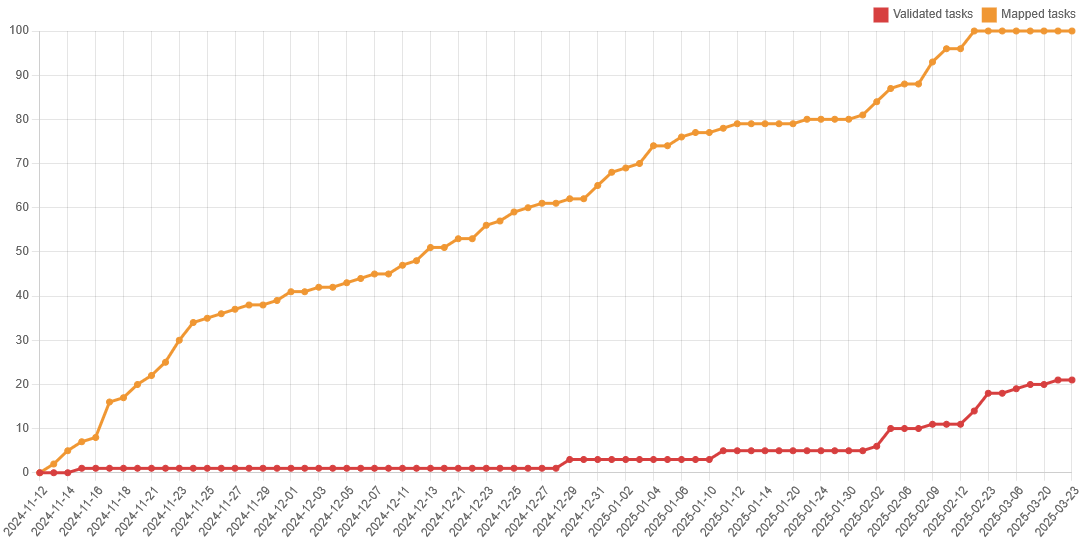
Louth (minus Dundalk) Task Mapped

On Valentine’s Day this year (pure coincidence, I’m sure), the Louth task was finished. Dundalk had been excluded from the task, because it had had its own task previously. The task had been opened on the 12th of November 2024, so it took only about three months to complete. To Read more

By Anne-Karoline, 1 year23-Mar-2025 ago
Recent Posts
  • Map n Chat Easter 2026
  • Using Ohsome for Task Server Projects
  • Mapping Complete on County Down
  • Belfast Mapping Event
  • Belfast Mapathon
Upcoming Events (Global)
  • Social Mapping Event in Parramatta
  • FOSSGIS-OSM-Communitytreffen im Linuxhotel
  • 大理三月民族节
  • MA1PPING
  • Workshop: JOSM - Java OpenStreetMap Editor - Eine Einführung
  • OSM India - Monthly Online Mapathon
  • Mappando si Vinci! - 2 Maggio 2026
OSM for History Buffs
  • Adding architectural data to a Wikidata item for a Historic Building
  • Creating a Wikidata item for a Historic Building
  • What is earth mortar and how can I record it using open data?
  • Michael Ring Blacksmith Gravestone #history #1798
  • Magnetic Cloister #experimentalarchaeology #3dprinting
Forum Discussions
  • Validating phone numbers in Ireland
  • Mangled ref:name from import
  • [SOLVED] How would this Click and Collect be tagged?
  • New Tasking Manager project: Add Missing Buildings in Ballybricken, Ireland
  • Richmond Hill in Cork city

OpenStreetMap Ireland Company Limited Registered company number 638034

General
  • Log in
  • Entries feed
  • Comments feed
  • WordPress.org
Categories
Archives

  • Home
  • About
  • Learning
  • Missions
  • News
  • Léarscáil
  • Contact
Hestia | Developed by ThemeIsle

OpenStreetMap Ireland Cookies Policy

Our Website uses cookies to improve your experience. Please visit our Privacy Policy page for more information about cookies and how we use them.

Close