OpenStreetMap IrelandOpenStreetMap Ireland
  • Home
  • About
    • Membership
    • Corporate Members
    • Member Login
    • Who uses OpenStreetMap?
  • Learning
    • For Beginners
    • For Historians
      • How to fix wrong townland names spotted on townlands.ie
    • For Educators
    • For Developers
    • Tools
      • Mapillary street-level imagery
      • Panoramax Street-Level Imagery
      • OSMAnd Mobile App
      • Visualising Your Contributions
      • Using overpass-turbo to extract data from OpenStreetMap
  • Missions
    • AED Defibrillator Mapping
    • Current Mission Tasks
    • Completed Missions
      • Mapping Progress per County
      • Balbriggan
      • Celbridge
      • Connemara
      • County Cavan
      • County Clare – North
      • County Donegal
      • County Leitrim
      • County Roscommon
      • Longford Town
      • #MapLesotho
      • MapPatrick 2021
      • Wild Atlantic Way
  • News
  • Léarscáil
  • Contact

Mapping East Mayo

Published by Jonny McCullagh on 14-Sep-202414-Sep-2024

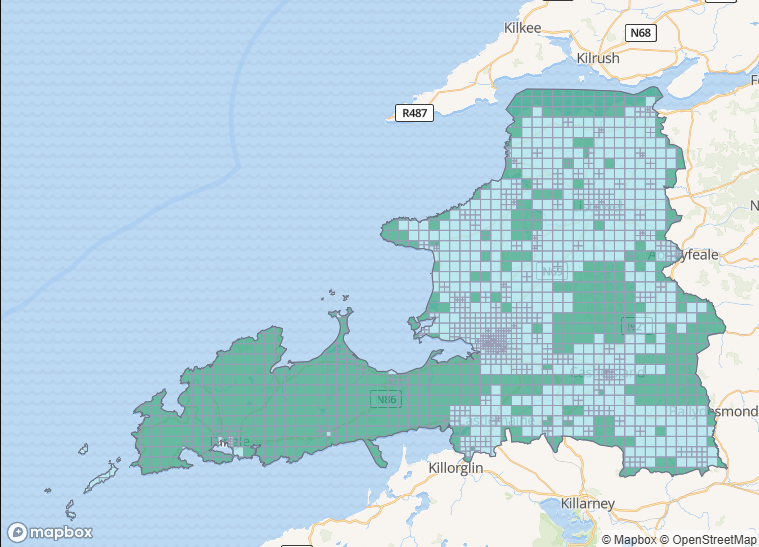
b-unicycling celebrates a 10 millionth edit and OpenStreetMap’s recent 20th anniversary by live stream mapping in East Mayo using the JOSM editor. You can join in with the task here: https://tasks.openstreetmap.ie/projec…. The video describes settings and plugins.

Categories: OSM Ireland Buildings
Tags: JOSM

Recent Posts
  • Using Ohsome for Task Server Projects
  • Mapping Complete on County Down
  • Belfast Mapping Event
  • Belfast Mapathon
  • North Co. Galway task mapping finished
Upcoming Events (Global)
  • A Mapathon to enrich participatory mapping of short supply chains around the Tokikoa label in the Basque Country
  • Missing Maps London: (Online) Mid-Month Mapathon [eng]
  • Mappy Hour OSM España
  • OSM térképest – március
  • Réunion du groupe local de Lyon
  • 198. OSM-Stammtisch Bonn
  • Lüneburger Mappertreffen (online)
OSM for History Buffs
  • Creating a Wikidata item for a Historic Building
  • What is earth mortar and how can I record it using open data?
  • Michael Ring Blacksmith Gravestone #history #1798
  • Magnetic Cloister #experimentalarchaeology #3dprinting
  • Mapping Quin #openstreetmap #opendata #countyclare
Forum Discussions
  • New Tasking Manager project: Add Missing Buildings in Ballybricken, Ireland
  • Richmond Hill in Cork city
  • Lack of mapped buildings in some counties
  • Overpass server for Ireland and Britain
  • Anyone familiar with bus routings in Derry around Foyle St and Craigavon Bridge?

Related Posts

County Down
OSM Ireland Buildings

Using Ohsome for Task Server Projects

The Ohsome website allows generating statitics but expects the input as a list of coordinates rather than geojson. The first step is to download a goejson shape of the project from the Task Server – Read more

County Down
OSM Ireland Buildings

Mapping Complete on County Down

After close to three years, the task of mapping all the buildings* in Co. Down was completed 13th March 2026. Progress was typified by larger squares in the earlier years of the project (poor design Read more

Map showing part of Co. Galway mapped during a mapping project
Open Data

North Co. Galway task mapping finished

The North Co. Galway task one was one I (b-unicycling) created and due to technical issues with the task manager could not publish for the first couple of weeks, so I was the only mapper Read more

OpenStreetMap Ireland Company Limited Registered company number 638034

General
  • Log in
  • Entries feed
  • Comments feed
  • WordPress.org
Categories
Archives

  • Home
  • About
  • Learning
  • Missions
  • News
  • Léarscáil
  • Contact
Hestia | Developed by ThemeIsle

OpenStreetMap Ireland Cookies Policy

Our Website uses cookies to improve your experience. Please visit our Privacy Policy page for more information about cookies and how we use them.

Close