OpenStreetMap IrelandOpenStreetMap Ireland
  • Home
  • About
    • Membership
    • Corporate Members
    • Member Login
    • Who uses OpenStreetMap?
  • Learning
    • For Beginners
    • For Historians
      • How to fix wrong townland names spotted on townlands.ie
    • For Educators
    • For Developers
    • Tools
      • Mapillary street-level imagery
      • Panoramax Street-Level Imagery
      • OSMAnd Mobile App
      • Visualising Your Contributions
      • Using overpass-turbo to extract data from OpenStreetMap
  • Missions
    • AED Defibrillator Mapping
    • Current Mission Tasks
    • Completed Missions
      • Mapping Progress per County
      • Balbriggan
      • Celbridge
      • Connemara
      • County Cavan
      • County Clare – North
      • County Donegal
      • County Leitrim
      • County Roscommon
      • Longford Town
      • #MapLesotho
      • MapPatrick 2021
      • Wild Atlantic Way
  • News
  • Léarscáil
  • Contact

Christmas 2022 Challenge

Published by Jonny McCullagh on 27-Nov-202227-Nov-2022

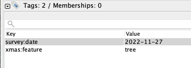
For some fun this Christmas we would like to tag as many public Christmas trees as possible. Add the trees in your local area using the tags:

xmas:feature = tree

In JOSM that might look like:

The trees can be visualised on Overpass Turbo

Instruction video for adding Christmas Trees using the OSMAnd mobile app:

Categories: Fun

1 Comment

Miche101 · 19-Dec-2022 at 20:25

https://community.openstreetmap.org/t/xmas-map-for-openstreetmap/7000

Xmas Map

Comments are closed.

Recent Posts
  • Map n Chat Easter 2026
  • Using Ohsome for Task Server Projects
  • Mapping Complete on County Down
  • Belfast Mapping Event
  • Belfast Mapathon
Upcoming Events (Global)
  • OSM India - Monthly Online Mapathon
  • A Synesthete's Atlas: Cartographic Improvisations between Eric Theise, Jeffrey Gordon Evans, Hannah Joyce, and Steev Hise
  • OSM Lucknow Mapping Party No.3
  • Mapatón humanitario
  • OSM-Treffpunkt
  • Easter 2026 Map n Chat
  • Missing Maps London: (Online) Mapathon [eng]
OSM for History Buffs
  • Adding architectural data to a Wikidata item for a Historic Building
  • Creating a Wikidata item for a Historic Building
  • What is earth mortar and how can I record it using open data?
  • Michael Ring Blacksmith Gravestone #history #1798
  • Magnetic Cloister #experimentalarchaeology #3dprinting
Forum Discussions
  • Mangled ref:name from import
  • [SOLVED] How would this Click and Collect be tagged?
  • New Tasking Manager project: Add Missing Buildings in Ballybricken, Ireland
  • Richmond Hill in Cork city
  • Lack of mapped buildings in some counties

OpenStreetMap Ireland Company Limited Registered company number 638034

General
  • Log in
  • Entries feed
  • Comments feed
  • WordPress.org
Categories
Archives

  • Home
  • About
  • Learning
  • Missions
  • News
  • Léarscáil
  • Contact
Hestia | Developed by ThemeIsle

OpenStreetMap Ireland Cookies Policy

Our Website uses cookies to improve your experience. Please visit our Privacy Policy page for more information about cookies and how we use them.

Close